
One of the most powerful storm systems to hit Western Australia in decades has left a trail of destruction across the state and is now moving east, bringing dangerous weather conditions to South Australia and other southern regions.
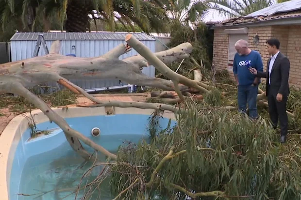
The massive weather system swept from Geraldton to Albany, tearing roofs from homes, toppling trees, and leaving thousands of residents without electricity. Flooding caused ceilings to collapse in several properties, while fallen trees crushed vehicles and damaged homes across Perth’s suburbs.
In Subiaco, two cars were destroyed after a large tree fell on them. Homes in Kwinana and Rockingham also suffered significant damage, with strong winds knocking down fences and even brick walls.
“Mother Nature is really cross with us. I don’t know what we’ve done wrong, but there you go,” resident Heather Hall said.
Rottnest Island recorded wind gusts of 113km/h, the strongest in the Perth metropolitan area, while Cape Naturaliste in the state’s south-west was hit by gusts reaching 135km/h.
Huge waves measuring up to 10 metres battered the coastline near Bunbury, causing severe coastal erosion.
Western Australian Energy Minister Amber-Jade Sanderson described the storm as one of the strongest weather systems experienced in many years.
“The Bureau of Meteorology has confirmed that this is one of the most powerful storm systems we’ve experienced in a number of decades,” she said.
The severe conditions also disrupted air travel, with four flights diverted from Perth to Kalgoorlie due to dangerous winds. Stranded passengers were forced to spend the night at the airport terminal.
“It was really foggy and turbulent. It looked really scary,” one passenger said.
Authorities expect the clean-up effort across Western Australia to take several days.
South Australia Braces for Severe Conditions
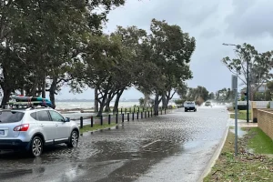
After causing widespread disruption in Western Australia, the storm system has now moved into South Australia, bringing damaging winds, hail, dust storms, heavy rain and dangerous coastal conditions.
Thousands of South Australians lost power on the first day of winter as severe weather warnings were issued for Adelaide and large parts of the state.
Residents have been urged to prepare for damaging winds, heavy rainfall, abnormally high tides and possible flooding. A storm surge warning was issued for Middle Beach, north of Adelaide, where flooding could isolate the community.
The State Emergency Service (SES) warned that in some areas it may already be too late to make preparations.
“For some areas, it may already be too late to prepare, particularly if your area is already being impacted by those winds,” SES Chief of Staff Robert Charlton said.
Emergency crews have already been called to clear fallen trees and debris from roads, including in Birkenhead, where trees crushed several vehicles.
Hailstorms struck Kanmantoo in the Adelaide Hills, while a large dust storm swept through Port Pirie in the state’s mid-north region.
Meteorologists expect the stormy conditions to continue until at least Wednesday.
“It’s definitely going to bring in winter weather, with a lot of cool air behind it. You’ll certainly feel the change,” Bureau of Meteorology forecaster Daniel Sherwin-Simpson said.
Victoria, NSW and Tasmania next in line
Weather experts warn the storm system will continue moving across southern and south-eastern Australia during the coming days, affecting Victoria, Tasmania, New South Wales and the ACT.
Weatherzone meteorologist Ben Domensino said damaging wind gusts are expected across parts of South Australia and Victoria, including Adelaide, Melbourne and surrounding areas.
“Damaging winds are also likely to spread into parts of New South Wales from Tuesday, particularly across the southern and central ranges,” he said.
The Bureau of Meteorology has warned that New South Wales alpine regions could experience wind gusts of up to 125km/h, with blizzard conditions possible above 1,900 metres.
The Blue Mountains, including the popular tourist town of Katoomba, could face sustained winds of 60km/h with gusts reaching 90km/h.
Large parts of Victoria, including Bacchus Marsh and Yarra Glen on Melbourne’s outskirts, are also expected to experience damaging winds.
Forecasters say some areas of Victoria and New South Wales could receive more than 100mm of rain this week, increasing the risk of flooding.
“There may be enough rain to cause flooding in parts of Victoria and southern NSW, particularly in elevated areas where rainfall totals could exceed 100mm,” Domensino said.
Emergency services across the affected states are urging residents to secure loose outdoor items, move vehicles away from trees, and stay at least eight metres away from fallen power lines.
Authorities continue to monitor the fast-moving weather system as it tracks across southern Australia.